


Méribel Roc de fer par les granges

jfcontour
User
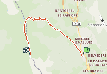

Length
6.4 km

Max alt
2282 m

Uphill gradient
860 m
Km-Effort
15.1 km

Min alt
1443 m

Downhill gradient
22 m
Boucle
No
Creation date :
2019-12-31 10:31:20.358
Updated on :
2019-12-31 15:00:19.828
2h27
Difficulty : Very easy

FREE GPS app for hiking
 SityTrail
IGN / Geographical institutes
SityTrail Plus
The world is yours!
About
Trail Touring skiing of 6.4 km to be discovered at Auvergne-Rhône-Alpes, Savoy, Les Allues. This trail is proposed by jfcontour.
Positioning
Country:
France
Region :
Auvergne-Rhône-Alpes
Department/Province :
Savoy
Municipality :
Les Allues
Location:
Unknown
Start:(Dec)
Start:(UTM)
309502 ; 5029442 (32T) N.
Comments